City of York Council are consulting on improvements for pedestrians and cyclists on the riverside path between Scarborough Rail Bridge and Jubilee Terrace.
Two approaches are being proposed;
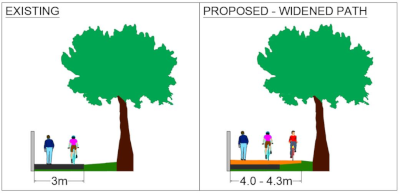
Approach 1 is to widen the path keeping it as a shared path between cyclists and pedestrians,
Approach 2 is to formalise the desire line path as a new pedestrian path and convert the existing path to a separate cycle path.

The Campaign supports proposals to improve the Riverside Path between Scarborough Rail Bridge and Jubilee Terrace, and believes that ‘Approach 2’ – the creation of segregated paths – is the optimal solution.
We’d like to thank member David for helping to draft the campaign’s response, and all members who provided feedback to the campaign and also took part in the consultation individually. The consultation closes on the 8th January and can be found on the councils website.
Context
- The route is a very well-used active travel connection between ‘The Island’ neighbourhood (Salisbury Terrace, Aldborough Way, Garfield Terrace etc.) and the city centre. Its popularity can be attributed to the proximity of the neighbourhood to the city, as well as the path being the most direct route for circa 1060 households, as well as the fact that the majority of those households don’t have off-street parking, limiting private car ownership for many. This suitability of the neighbourhood for active travel is self-fulfilling, with many residents naturally choosing active travel as the most convenient means to access the city, and active travel users choosing to live in the neighbourhood in the first place because of its proximity and suitability.
- Its high utilisation is most evident during daytime and in fair weather, but is in stark contrast to the low utilisation at night, and obviously near-zero utilisation at times of flood. At such times, active travel users are more likely to use Leeman Road as a circuitous alternative with the trade off being that it is safer and more dependable.
- The current arrangement of the path is segregated between cyclists and pedestrians using a white line. However, the designation of the two sides is only signified by faded painted cycle symbols in a limited number of places, so the arrangement isn’t clear to all users. More importantly, the inadequate width of the path forces some users to traverse the line, for example when pedestrian groups, wheelchair users or pushchair users pass each other and spill on to the cycle side, or when cyclists pass each other and use the pedestrian side to give each other adequate space. At peak times this inevitably causes frustration for all users and contention for space.
- The discomfort for pedestrians of the contended space is clearly evident by the fact that pedestrians have literally ‘voted with their feet’ and created a desire-line path in the grass on the north side of the tree line. This serves well in fair weather, whereby pedestrians are actively avoiding the clashes for space, but doesn’t serve well in Winter when the desire-line path is too muddy to use.
- Whilst the route is lit, the arrangement of tall lamp-posts within the tree canopy makes them ineffective for significant parts.
- The appeal of the route is sometimes undermined for all users because of a lack of maintenance to clear leaves, gritting and poor drainage in places. This can make the route notoriously treacherous in winter, especially when a layer of crushed leaves subsequently freezes over.
- The vegetation on the Network Rail side of the wall sometimes grows over the wall and can hang into the path. Cyclists, being slightly higher than pedestrians, are more likely to encounter this as a problem. However, Network Rail and local volunteers do a reasonable job of pruning back occasionally.
- There is signage on Jubilee Terrace which is intended to signify when the route is impassable due to flooding. However, many users have been conditioned to disregard the sign, since it is often showing out of sync with actual times that the route is impassible (either not shown soon enough, or remaining shown long after the flood has passed). This is quite frustrating for those travelling west-bound, since the distance covered along the route before discovering the route is blocked is significant. This does lead to some users taking inappropriate risks, for example cyclists cycling through the flood water, and also pedestrians have been observed jumping the wall to walk beside the railway.
York Central
- Whilst the riverside path improvements are not within the defined scope of York Central, their importance was made clear both at the public enquiry to the Stopping Up Order, and within the reserved matters application for the Railway Museum Central Hall. The need to improve the safety and dependability of the riverside route already exists regardless of York Central, but its importance and urgency is elevated by the closure of Leeman Road.
- For the majority of riverside path users, Leeman Road presently offers an essential alternative for times when the riverside route is impassable due to flood, or is chosen at the residents discretion, trading off a longer route for the increased personal safety of using a well-lit, well-used through road and it’s natural surveillance. The stopping up order has made the trade-off of distance worse, and has decreased the benefit of safety since the newly formed ‘Leeman Road West’ will be a cul-de-sac rather than a well-used through route, and the connecting route between the Railway Museum and the new Government Hub building will also not enjoy good natural surveillance outside of office hours and museum opening hours.
- In the Report to the Secretary of State for Transport, following the Stopping Up Enquiry, the inspectorate commented on the importance of the riverside route improvements in the context of the closure.
- 9.90 “Following the stopping up of Leeman Road the alternative journey, via Foundry Way and Hudson Boulevard, would be twice as long as that via the Riverside Route. I agree that this could feel to many of those users as a compromise on top of a compromise”
- 9.91 “I accept that the stopping up of Leeman Road could make this primary route more important for a proportion of the existing residential community”
- 9.91 “Both the importance of the Riverside Route and the fear that residents have about their increased reliance on this route if Leeman Road is stopped up … are clearly matters of very significant local concern.”
- 9.92 “The Riverside Route is in need of upgrading to enhance the safety of users and reduce the number of days on which it is impassable due to flooding”
- 9.93 “…the Council should be encouraged to carry out the works, if possible, before Leeman Road is stopped up”
- The Reserved Matters application for the Railway Museum Central Hall (21/02793/REMM) featured a Transport Plan which featured the Riverside Route (page 10 – Brown line on map) and described it as “Existing riverside route to be improved”, clearly documenting that the transport implications of the plans were designed with the assumption that the riverside improvement would be made.
Balancing cyclist and pedestrian needs
- We believe that the desire-line footpath in the grass north of the treeline suggests ‘Approach 2’ of the consultation is the optimal solution. Creating a distinct pedestrian path that follows a more direct line-of-sight route, with two-way cycle traffic using the existing path. We believe this is optimal as per LTN 1/20 section 8.2.3 which encourages creating separate routes where possible.
- As the desire line path shows, pedestrians prefer to use the shorter and more direct route, so would be more likely to misuse the cyclepath as a footpath with this arrangement. Also, some of the footpath users are dog walkers, and there is less chance of cyclists coming into conflict with a dog if the cyclepath is nearest the wall.
- If such a design is chosen there would be transition points between shared and segregated cycle/pedestrian provision at both ends, plus also access to the Aldborough Way access ramp for pedestrians would involve crossing the cycle path. LTN 1/20 section 9.4 provides guidance on such transitions which we’d like to draw the attention of designers to.
- The pinch-point at the Scarborough Bridge access point is of particular concern. It is acknowledged that this is a particularly difficult place to improve, although the question of whether it’s possible to open up and utilise the bricked up arch somehow should at least be assessed. LTN 1/20 section 8.3.2 advises against signage instructing cyclists to dismount since they are not legally enforceable and discriminate against cycle-as-mobility-aid users.

Leave a comment