
At the end of August a consultation was launched between City of York Council and West Yorkshire Combined Authority (WYCA) for changes to Tadcaster Road which are stated ‘a series of walking, cycling and bus improvements along the Tadcaster Road which will help provide a more attractive, safer and convenient route for all.’
Proposals can be viewed on a WYCA Your Voice consultation page at yourvoice.westyorks-ca.gov.uk/TadcasterRoad, and comments submitted up until September 19th.
A team of members have been raking through the proposals, and comparing them against the latest cycle infrastructure design guidance LTN 1/20, in order to pull together the Campaign’s response. Below we share some of our first impressions that you may find useful if you want to make your own contribution to the consultation.
Advisory to Mandatory
Large sections of the proposal are ‘upgrades’ of the advisory cycle lanes along Tadcaster Road to mandatory cycle lanes which are generally 1.8m in width. This is being achieved through the reduction of traffic lanes in places and removal of some other features within the road.
Advisory cycle lanes are marked with a dashed line and the most predominant form of cycle infrastructure around York. They have no legal status but rule 140 of the Highway Code states ‘Do not drive or park in a cycle lane marked by a broken white line unless it is unavoidable.’
Mandatory lanes are marked with a solid line and whilst some exist in York they’re much less common. Unlike advisory lanes they do have a legal status – rule 140 states ‘ you MUST NOT drive or park in a cycle lane marked by a solid white line during its times of operation’. Contrary to some beliefs, there is no legal requirement for cyclists to use a mandatory lane (or advisory) if present.
As most cyclists will know, the benefits of ‘painted lanes’ such as advisory & mandatory cycle lanes are minimal. In fact a recent study in 2020 of painted lanes found that there was no reduction of collisions involving cyclists where mandatory lanes are installed, and where advisory lanes are used the number of injuries actually increases by 30%.
Following LTN 1/20 guidance the width of lanes should absolutely be no less than 1.5m wide where there are constraints, but the desirable minimum width is 2.0m. At a width of 1.8m, the proposed cycle lanes for Tadcaster Road fall just below the desirable minimum.
The suitability of painted lanes is also dependent on the speeds of the road they’re being applied to. Figure 4.1 in LTN 1/20 sets out what infrastructure types are suitable at what speeds.
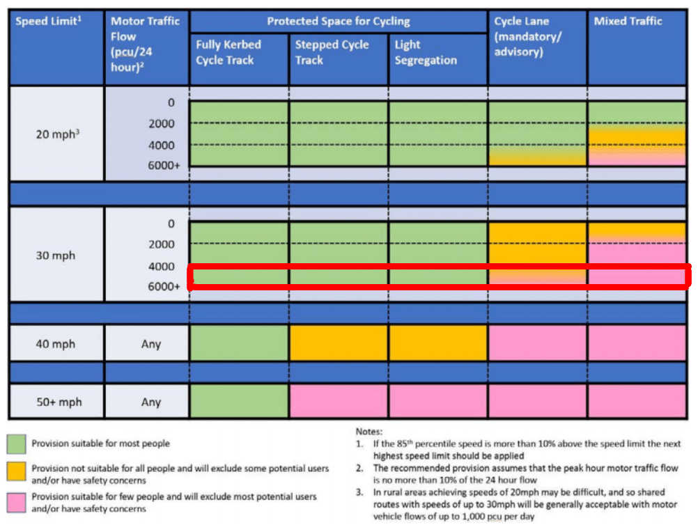
WIth a speed limit of 30 mph, and a motor traffic flow of well over 6000 PCU/24 hours the suitability of infrastructure can be found from the bottom row of the 30 mph route. As the box for cycle lanes is a mix of orange & pink,it indicates that this provision won’t be suitable for everyone. To improve this to being suitable for most people, changing the speed limit to 20 mph still doesn’t put the provision completely ‘in the green’, to do this some form of protected space for cycling is required such as light segregation, a stepped cycle track, or a fully kerbed cycle track.
Better Protection
To provide safer and more attractive infrastructure for all cyclists along Tadcaster Road, LTN 1/20 recommends some form of protected space should be provided.
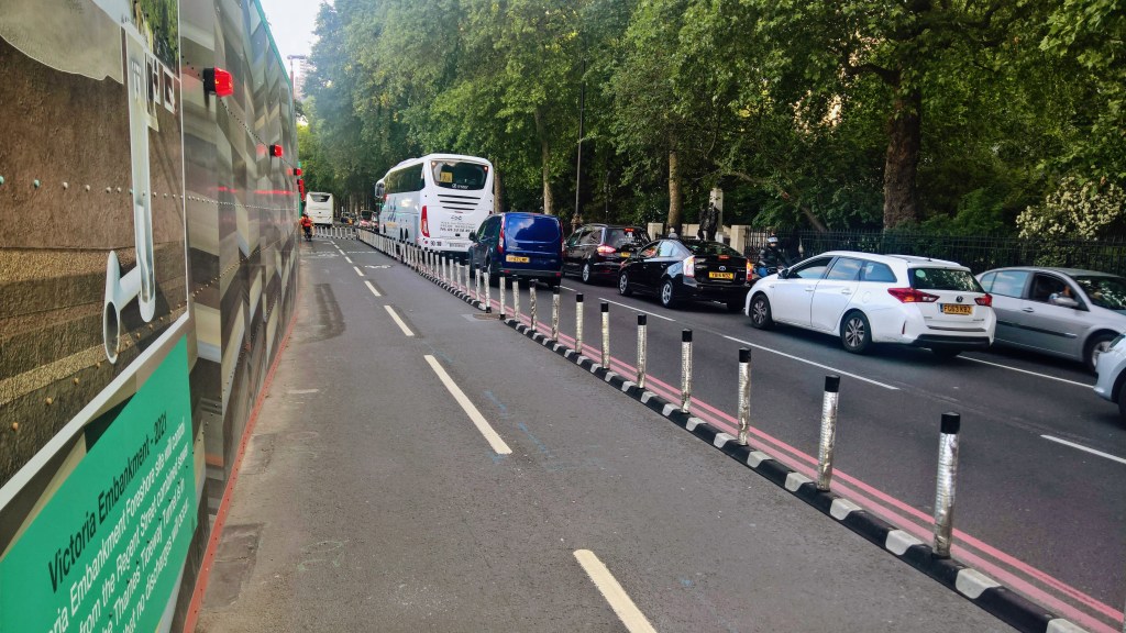
This could be through the installation of what is known as light segregation along the proposed lane. Light segregation refers to the use of physical objects installed along the edge of the cycle lane, these are often in the form of fixed poles known as ‘wands’ or low lying lumps commonly referred to as ‘armadillos’ due to slight resemblance to the armour plated critter. Light segregation prevents motor vehicles from entering the cycle lane and is a great way to increase the perception of safety along the route as well as the visibility of the lane. They are also very effective in preventing the blocking of cycle lanes by parked vehicles, but where there are concerns that traffic might block emergency vehicles the spacing can be adjusted to allow vehicles to occasionally pull out of the way. It’s also easy to introduce breaks in segregation where they may be needed for access to driveways.
Being only made of plastic or rubber, light segregation methods are considerably cheaper than other forms of protected infrastructure so longer lengths of protection can be provided for the same cost. They also don’t need special authorisation to be used, so the installation should theoretically be easier bureaucratically.
Missing Priorities
Section A1 of the proposals covers from the junctions with Scarcroft Road to Albemarle Road, but it doesn’t take up the opportunity to rectify issues with priorities over sideroads from when this section of cycle path was last updated a few years ago.

Where the sideroads cross the cycle track, the cycle track is currently broken with ’give-way’ markings assigning priority to the side road. As the cycle track forms part of the main road, even segregated as it is, the track should get priority over any side road joining onto it not only for convenience but for safety so everyone is aware of what is going on.
Following the design standards set out in LTN 1/20, the cycle track would be given priority over these side roads. The standards give multiple options of how this can be achieved with different levels of marking and set-back depending on the situation.

A Smarter Junction?
Changes are proposed to the traffic light junction with St Helen’s Road, just next to the Cross Keys pub. Proposal drawing A5 says that the ‘junction operation will be changed to MOVA’… We didn’t know what that meant either, but thanks to the power of Google we now know it stands for Microprocessor Optimised Vehicle Actuation…
Some further Googling tells us it’s a traffic light that’s smarter than your average traffic light, using sensors to monitor traffic flows on the different routes and adjust timings accordingly to try and ensure the best flow of traffic – pretty smart!
However, working through the consultation questionnaire there’s more proposed to this junction that isn’t declared on the drawings that’s not as smart, in fact we don’t think it’s a clever idea at all. The questionnaire asks peoples views on ‘Providing a specialist traffic light signal button to allow people on bikes to request an earlier start.’
Having an earlier start for cycles is a great idea, most traffic lights should have one especially if they’ve been given an advanced stop area. There are many of these already around the city, and the process is pretty simple; ride up, wait, the cycle light goes green, you get away safely before the traffic. Including a button means that the lights would work differently to all other early release lights in the city. It also has huge potential to discriminate against cyclists that don’t have the ability to manoeuvre themselves into the position required to reach and press the button such as riders on tricycles, recumbents, cargo bikes, or with trailers. This in turn will mean that they are excluded from the safety benefits of having an early release. Instead automatic detection of cyclists should be used; as is already used across the city and is proposed for buses at this very junction.
Let’s Go Dutch
Section A8 of the proposals covers the roundabout at Askham Bar Tesco, an incredibly busy junction with a cycle path around the edge that repeatedly swaps sides with the footpath and is shared with it for the rest. None of the widths of this path meet the standards, with several blind spots and pinch points, and the islands to the crossings aren’t large enough for cyclists and pedestrians to use at once. It’s also not convenient; a lap of the roundabout is 175m, a lap of the cycle path is over twice that at 400m and all but one arms off the roundabout have signalised junctions that don’t favour pedestrians/cyclists.
The design proposals for this part of the scheme range from new guardrails to providing a new 45cm offset from two of the kerbs by relocating those guardrails.
For a better solution to Moor Lane Roundabout, we should take inspiration from across the North Sea where in the Netherlands cycle lanes are regularly placed around larger roundabouts with priority crossings to allow safe and convenient routes through roundabouts for cyclists. Roundabouts of this style are covered in LTN 1/20, featuring direct, clearly defined routes around the roundabout and safe crossing across each arm.

On routes with higher traffic flows it is possible to swap the zebra style crossing for signalised crossings, like those already present on Moor Lane Roundabout, to better control traffic and provide additional surety that motorists will come to a stop.
Sim Balk Lane, and Beyond?
The last identified proposal heading out of the city is a widening of the shared space opposite York College, however the scheme is declared as extending up to the Park and Ride. We believe there are still several opportunities beyond the college for improvements that just aren’t covered.
The narrow blind corner on the shared path next to the Sim Balk Lane traffic lights is unmentioned, but could be resolved by some widening of the path and battering back the retaining wall to improve visibility.
The restricted gateway into the park & ride and the steep corkscrew descent onto the NCN 65 (Solar System Way) and its steep corkscrew descent could be picked up together to make a more welcoming entrance to the park and ride. This would be a fitting accompaniment to the Park & Pedal scheme offered and go hand in hand with the aim of improving active travel and public transport along the route.
Tadcaster Road doesn’t just lead to the Park & Ride but also onto Copmanthorpe but there’s no proposed benefit for their onward connections, such as formalising the desire line across the P&R entrance that is so well used it shows up in Google Maps.
Have Your Say
We hope in sharing our first thoughts on the scheme we’ve given you plenty to think about, and we’d encourage you to take part in the consultation yourselves.To do so visit yourvoice.westyorks-ca.gov.uk/tadcasterroad where you can find links to all the proposed plans and fill out a survey on what you think of the proposals. The consultation runs until the 19th of September 2021.

Leave a comment