
During September 2021, City of York Council and West Yorkshire Combined Authority (WYCA) consulted on design for changes for Tadcaster Road that aim to improve active travel and public transport along the key route in and out of the city.
Earlier in the month we shared our first impressions of the design, below we share our formal response that was submitted to the consultation in which we assess the designs against LTN 1/20 – the current guidance on providing cycle infrastructure produced by the Department of Transport.
The Core Design Principles
Section 1.5 of LTN 1/20 sets out that cycle infrastructure should be Coherent; Direct; Safe; Comfortable and Attractive.
Coherent
The scheme is not coherent in that there are poor connections to major attractors such as York College, Tescos, and NCN 665/65 at the Southern end and the City centre through Micklegate bar, the railway station and All Saints school at the Northern end.. There are unintuitive sections at the approach to the crossing at York College with a cycle lane inbound next to a cycle track outbound .
Direct
The route along Tadcaster road is fairly direct but rather longer at the Moor Lane roundabout which requires many stops to get around the roundabout on the much longer cycle tracks with frequent stops at signalled crossings. Outbound cyclists need to give way on The Mount on three occasions compared to using the road. Priority should be given to cyclists at all side road accesses in line with LTN 1/20.
Safe
No protected on-carriageway cycle lanes are shown on the proposals and the road will not feel safer than it does at present with slightly wider painted advisory and mandatory cycle lanes along it. Inbound along the Mount, where the bus lane is shortened, no cycle lane is proposed at two junctions which will lead to cyclists getting cut up by left turning traffic especially at Driffield Terrace..
Cycle lanes widths of 1.7m, 1.8m and 2.0m are shown on three cross sections of route sent to YCC at our request. 1.7m and 1.8m lanes are above the 1.5m minimum width in LTN 1/20 but below the desired minimum width of 2.0m. To understand and assess the proposals properly more cross sections should be provided showing cycle and traffic lane widths along the whole route.
The proposed conversion of the separated paths to a shared path along the Knavesmire will lead to unnecessary conflict with pedestrians. Separate paths should be retained and there is room to widen them both from the existing 3.0m separated wide path to 4.5m as recommended.
Junction treatments seem to be refreshing what is already in place. Very little new is planned at the Moor lane Roundabout with inbound cycle lane leading into the Roundabout with no cycle facilities on it and the transition from cycle path inbound from Moor lane onto Tadcaster Rd is dangerous with a narrow cycle lane sandwiched between a bus lay by and moving traffic. For Traffic signals ASL are retained which LTN 1/20 says are the least effective measure for cyclists and will not improve the perception of safety. More effective safety measures which separate cyclists in time and space such as hold the left turn, two stage right turns, low level signals with early release and signal bypasses at T junctions do not seem to have been considered
Comfortable
The new road surface is comfortable to use although it was dug up fairly soon after being resurfaced by Northern Gas. The widths of the proposed lanes are mainly below the desirable minimum in LTN 1/20 and the widths of shared paths at the minimum. Stopping and starting at Moor Lane Roundabout and outbound on the cycle track along the Mount can be reduced through priority crossings.
Attractive
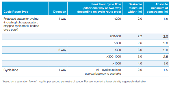
LTN 1/20 also has a useful table showing the sort of cycle protection that is needed with different traffic flows and speed limits.

Tadcaster Road has 16,000 passenger car units (PCU)/24 hours and is 30mph so the proposal of cycle lanes will exclude some/most potential users. In order to make the route attractive the guidance recommends that some form of protected space is provided, whether through kerb or light segregation, any of which would massively improve the attractiveness to all user groups.
Accessibility
LTN 1/20 is clear that an overarching principle of the above five principles is inclusive and accessible design. A route should be accessible for all types of cyclists and cycles. A design bike 2.75m long and 1.2m wide is suggested in LTN 1/20 to cover the range of cycles that will use a route and inform the design of lane and crossings. This size of bike would have trouble navigating the staggered signalled crossings at the Moor Lane roundabout and getting access to the NCN 665 entrance/exit at the Sim Balk Lane junction.
Assessment Tools
LTN 1/20 has two tools to review existing schemes and new proposals against the principles of LTN 1/20. It is not apparent from the consultation documents if these have been undertaken for the proposals, as no scores for the scheme have been provided or referred to. In lieu of such information, York Cycle Campaign has undertaken a review of the proposals using the information available.
Cycling Level of Service Tool (CLoS)
Reviews the whole route and uses the 5 core principles above to score a route on 25 indicators. Each indicator is scored from 0 to 2 where 0 means only experienced cyclists could use the facility e.g. an advisory cycle lane, while a score of 2 means anyone wishing to cycle could use it e.g. a protected bike lane of adequate width. .
YCC has scored the Tadcaster Rd route using CLoS and it scores 25 out of 50 points so 50%. The threshold for a route to receive funding from the DfT is 70%.
A completed copy of the CLoS is attached in Appendix A.
Junction Assessment Tool (JAT)
We have also carried out assessments on two signalled junctions. Sim Balk Lane scored 8 out of 40 as some of the movements can be made on cycle paths. St Helens Rd signals scored 0 out of 12 as all of the 6 movements made by bike are made with moving traffic and the right turn into St Helens Road requires crossing a moving traffic lane.
We recommend that CYC/WYCA carry out or commission an independent CLoS and JAT to review the existing proposals and make recommendations to improve the scheme. These results should be published.
A completed copy of the JATs is attached in Appendix B & C.
‘Section A0’: Holgate Road to Micklegate Bar
Whilst not specifically covered in the proposals, we feel that the section from the end of the proposals to Micklegate Bar is a key link in the success of any scheme and is currently being overlooked.
This is a crucial link to the city centre, station and All Saints school and there are five traffic lanes at the junction of Blossom Street with Micklegate with no cycle facilities. Road works to Micklegate Bar in the recent past have taken out the middle inbound lane without seemingly causing traffic chaos.
Protected bike lanes are desperately needed along this section and could easily be provided through the freeing up of that same inbound lane. This would encourage children to cycle to school safely, link in with the protected lanes proposed as part of ‘York Station Front’ scheme, and provide cyclists a safe link to the city centre.
Section A1: Tadcaster Road/Dalton Terrace
Nothing is proposed for correcting the priorities of the cycle path over side roads between Scarcroft Road and Ablemarle. This opportunity was missed when the path was revised a few years ago, but LTN 1/20 is quite clear that cycle paths should be given priority over side roads in paragraph 10.5.7 and figure 10.13. There is no clear reason why this hasn’t or can’t be included within this scheme.

At the junction with Scarcroft Road inbound cycles could be provided with a straight on green signal to bypass traffic signals and be given priority. For cyclists turning right turn onto Scarcroft Road an ASL is proposed which is the least effective measure at signals according to LTN 1/20. Instead a two stage right turn system could be made possible by allocating some of the cobbled area. For outbound cyclists the advanced cycle stop line and low level signals good start are beneficial, but could be further improved with an early release light and protection to the cycle lane.
At the junction of Dalton Terrace & Albemarle Rd, the inbound cycle lane requires protection and has a ASL proposed without a feeder cycle lane. As previously stated, the ASL is the least effective measure for cyclists at traffic signals – a hold left turn, two stage right turn, or early release would all remove safety for cyclists at this junction.
Section A2: Tadcaster Road/Knavesmire Road
Widening the cycle lanes in both directions by removing the right-hand turn pocket at St Aubyns Place, the splitter islands and revising the bus lane.
Agree but need to see details of cycle lane and traffic lane widths and cycle lanes require protection.
Revising the bus lanes – these are shortened on the approaches to the junctions at St Aubyns Place and Driffield Terrace and no cycle lanes are shown on the approach or across the junction – this will mean cyclists are in conflict with left turning traffic with no protection.
Whilst we agree with the increase in path, LTN 1/20 and Gear Change are clear that shared space should be avoided unless the alternative is cyclists having to use road space. In this case we question whether the path can be widened any further to allow a clearly designated separation between uses.
No improvements appear to be proposed to the slipway onto this path from the main carriageway. There are also no openings along it’s route to facilitate joining/exiting the path – of particular use to those living/visiting the houses opposite. The transition back onto the road at the Hob Moor crossing point is not gradual and is not clear to drivers.
There is an opportunity to extend the existing separate paths up to the Marriott Hotel. Pedestrian and cycling areas should be clearly designated as such to avoid conflict, as advised in LTN 1/20 though a protected cycle lane along the road is preferable where funds are available.
Section A3: Pulleyn Drive
Outbound – no cycle lane shown from just before Pulleyn drive southbound and plan does not appear to show shared use of sufficient width – plenty of room to move fence alongside Knavesmire and provide wider separate paths for cyclists and people walking.
This could create conflict between cyclists and pedestrians. The current separation of these users should be further enhanced by widening the complete path to the recommended width of 4.5m and remarking designated areas. Dropped kerb entrance points are also required to allow cyclists to enter this long stretch of traffic-protected route from smaller roads on the opposite side of Tadcaster Road as well as make right turns into them rather than try to do this turn between two lanes of traffic.
Section A4: Nelson’s Lane
Constructing a signal controlled crossing between Nelsons Lane and Chalfonts
Creating this crossing as a Toucan type crossing would also allow northbound cyclists to access the fully segregated path on the southern side of the road with greater ease and safety.
Section A5: Ainsty Grove to St Helens Road
Widening the road near Ainsty Grove to provide space for a wider pedestrian and cycle refuge
We feel that a better improvement for both cyclists and pedestrians would be to replace the refuge with a Zebra crossing with parallel cycle crossing, as has been installed along Heslington Lane to link University sports pitches.
Removing one of the pedestrian refuges near Mayfield Grove and widening the remaining one
Provision of a parallel crossing at the remaining crossing would provide safer crossing of inbound cyclists onto the shared path on the opposite side of the road. Signalising this crossing or providing a zebra would greatly increase safety and convenience for both pedestrians and cyclists.
Providing a specialist traffic light signal button to allow people on bikes to request an earlier start.
This is not an appropriate addition. Including a button means that the lights would work differently to all other early release lights in the city. It also has huge potential to discriminate against cyclists that don’t have the ability to manoeuvre themselves into the position required to reach and press the button such as riders on tricycles, recumbents, cargo bikes, or with trailers. This in turn will mean that they are excluded from the safety benefits of having an early release. Instead automatic detection of cyclists should be used; as is already used across the city and is proposed for buses at this very junction.
YCC have carried out a Junction Assessment for this junction and it scored 0 out of a possible 12 points as none of the cycle movements at it were protected in time or space. See Appendix B.
Section A6: Slingsby Shops
Adding a section of off-road cycle track so that people on bikes travelling inbound (towards the city centre) can by-pass the parking and bus stop.
We welcome the proposal of a bus stop by-pass as a good idea, but it should also apply inbound by the shops and Dringhouses library where the cycle lane is shown outside of the parking bays which is not good practice
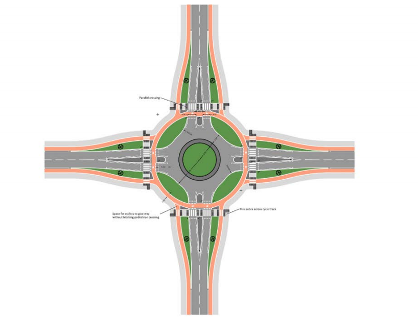
Section A8: Moor Lane roundabout
Proposal is a replication of the existing, with no ambition for improvement. Consider a whole redesign towards a Dutch style with more direct routes, that are closer to the apex of the corner with priority over each arm with zebra crossing.
Segregated route/footpath swaps side depending on the arm of the roundabout and there is a lot of wasted space at the roundabout with anti pedestrian cobbles which are a trip hazard
Accessibility audit for the roundabout done, compliance with Equalities Act 2010.
The only change at the roundabout is moving some guardrail which will narrow the footway and cycle track. This roundabout was designed in the 1980’s as part of the Tescos development and needs full review and redesign with options to either signal using CYCLOPs principles or convert to a Dutch Style roundabout with single lane entry, perpendicular entries to slow traffic and a annular cycle track with priority crossing for people walking and cycling across each arm.
Section A9: York College
The proposals don’t appear to provide any improvements to the connection with the NCN 655 Solar System route to Bishopthorpe and Copmanthorpe. We believe there is opportunity here for some consideration to be given to the existing spiral access to NCN 665 and either improve gradients to standards in LTN 1/20. Alternatively assessing other access points such as a crossing on Sim Balk Lane signals to link with the new ramp down to NCN 665, a route which is currently rough trod by students and others down the side of the A64 bridge, or using existing track opposite York College to the new sports pavilion.
A better entrance to NCN 655 and P&R could be made by moving vehicle restraint barriers to the road’s edge on the currently cobbled area, allowing a widening of the entry path. This should be combined with lowering and reducing the hedges by entrance to improve visibility.
YCC have carried out a draft Junction Assessment of the Sim Balk lane junction using the JAT tool in LTN 1//20 Appendix B, scoring only 8 points out of a posible 40. A copy of our evaluation is included in Appendix C.
Crossing of the road for pedestrians and cyclists could also be significantly improved with the introduction of a 20mph zone, and supporting speed calming features, along the frontage of York college in line with the city’s policy of 20mph outside education establishments with speed table at existing toucan crossing and consider converting to parallel crossing.
Adding an dedicated off road cycle track so that people on bikes travelling outbound (towards York City ) can by-pass the bus stop. This facility would require the removal of trees.
The proposed layouts south of the junction of an inbound lane/outbound track next to each other but in mirrored directions to what is conventional on UK roads is unclear and potentially hazardous.
We also foresee a conflict of use from pedestrians coming from/leaving the college walking along the proposed cycle track conversion to the bus stop. A more appropriate move would be to make the existing shared use path by Tescos wider to enable separate paths for people walking and cycling as it provides a bus stop bypass already, and replacing the bus cage with a bus layby.
No proposals are apparent for dealing with the blind corner on the junction with Sim Balk Lane alongside the burial ground. There is the potential to rake back the retaining wall on the corner to improve visibility for both pedestrians and cyclists.
‘Section A10’: Beyond York College
The section of Tadcaster Road beyond York College is not covered in the consultation documents, however it was included in the scoping map available from CoYC.
We feel that the entrance into P&R the route should be realigned to follow the desire line across the entry and exit lanes; this desire line is well formed and clearly evident on site and significantly shortens the journey of both pedestrians and cyclists.
Comments on the Consultation Process
The level of information provided in the technical drawings fluctuates highly, in places simple matters such as lane widths are lacking but in other areas are highly refined such as the movement of guardrails by the millimeter. All the information provided is highly technical in its presentation, relying on any observer to have the ability to read and comprehend street plans in order to make an informed decision. If members of the public are to be involved it should be in a way that is inclusive of all such as demonstrative sections showing the proposed widths, CGIs of key parts of the route or proposals, and precedent images of similar interventions locally or nationally.
It is unclear if the priorities outlined in the consultation webpage are correct. They are not aligned with climate change act obligations to reduce over GHG emissions, and DoT stated objectives for making space for active travel. The focus appears to be reducing (car) traffic congestion to achieve air quality improvements.
Whilst there has been efforts made to promote the consultation on social media, the Campaign is not aware of any publicity being made along the route itself to actual users of the route – especially those that might not have access to social media channels.
No information has been provided on current cycling, walking and motor traffic usage levels, Road traffic casualties, air quality or traffic speeds along Tadcaster Rd. Most of this information is publicly available on various web sites eg. Bike Data. It is also needed for making the case for the scheme and for monitoring the effectiveness of the measures. For example; how is air quality – one of the stated aims of the scheme – to be monitored? How many people cycle along Tadcaster Road now and what is the trend? What is the business case for the scheme and the main benefits?
We are also disappointed that York Cycle Campaign (and other cycle user groups) hasn’t been consulted directly and offered an opportunity to meet with the design team – stakeholder engagement such as with local campaign groups being recommended during the design process within LTN itself.
Leave a Reply