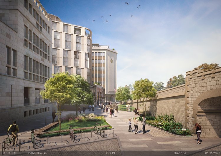
In January developers re-submitted plans for a mixed-use development on Rougier Street, consisting of offices, a hotel, flats, and a new museum exhibiting the city’s Roman heritage – earning the development the ‘Roman Quarter’ name. The project reimagines the development which was rejected on its first application, after numerous objections to its appearance.
The project, which sits alongside Lendal Bridge, includes two key cycle links from Rougier Street to the riverside route Wellington Row; Tanner’s Moat and Tanner Row. The submitted designs propose a cycle path through a newly pedestrianised Tanner’s Moat, and a more distinct contraflow down Tanner Row.

The Campaign have written a response to the planning application with the help of some members, using the Cycle Level of Service tool (CLos) provided in Appendix of the national design guide LTN 1/20. The CLoS allowed members to work through the scheme scoring it against set criteria.
Generally the scheme scored highly, a reflection of how it provides for cyclists, however it it scored a ‘critical fail’ due to the contraflow running close to parking bays without suitable width and a lack of parking for hotel guests. Unfortunately because of this the Campaign has felt it necessary to lodge the response as an objection – unless these features can be resolved.
The Campaign hopes to further develop its use of the CLoS to respond to planning applications, allowing it’s members to respond to greater amount of planning applications efficiently and consistently.
Our response to the application follows below;
1. Summary
This comment has been put together with the assistance of members of York Cycle Campaign, relating to the application for the ‘Demolition of 1 – 9 Rougier Street and erection of mixed use development’ also referred to the Roman Quarter Project. The comment looks at the proposed cycle routes (section 2) and proposed cycle parking (section 3).
The scheme shows improvements cycling within the application boundary, which is in line with local and national policy notably;
- NPPF paragraphs 85, 92, & 112,
- Local Transport Note 1/20,
- Draft York Local Plan (2005) policies GP4a, T2a/b, T4, L4, V1, V3,
- Proposed York Local Plan (2018) policies DP2, DP3, D1, T1, T7,
On the whole the scheme makes a positive improvement, although there are points requiring further consideration which are outlined in detail in the sections below. However the Campaign feels it must object to the proposal due to two issues.
- When tested against the LTN 1/20 CLoS toolkit, the Tanner Row section scores a critical failure in the Safety section due to the width of the cycle lane alongside kerbside activity – see section 2.2.3.
- When the parking allocation is compared to the local requirements, the parking for hotel guests is substantially lower – see section 3.1.
Should these two elements be suitably revised, we would be happy to amend our comment to one of support for the scheme.
2. Proposed Cycle Routes
Local Transport Note 1/20, Cycle Infrastructure Design, recommends that cycle route proposals are assessed and scored using a Cycling Level of Service tool which is provided in Appendix A of that document. A completed assessment has not been included in the planning application, but the Cycle Campaign has undertaken its own assessment of the proposed routes using the tool which has formed our responses to the application in this section.
Tanner’s Moat and Tanner Row are two distinct routes, and have been covered under two assessments, which are broken into the five follow sections as follows;
- Cohesion measures how well connected the cycle route is to other sections of the cycle network, and how easy those connections are.
- Distance is a measure of how direct the route is, and how many delays cyclists encounter whilst using that route.
- Safety considers the appropriateness of the type of infrastructure along the route, in particular its relationship to motor vehicles.
- Comfort considers how comfortable the route is to ride physically in terms of materials used, as well as personal comfort in terms of width given and ease of wayfinding.
- Attractiveness section looks at how likely the cycle route is to attract people to use it.
2.1 Tanner’s Moat
Overall this area of the proposal scored 80%, over the recommended pass level of 70% and an improvement on the existing infrastructure which scored 77%. However CLoS tool raises some weaknesses which are discussed below.
2.1.1. Cohesion
There is no change in the scoring of the Cohesion section of the CLoS tool, with the area scoring 6 out 6 before and after.
The high score is due to being in a well connected part of the city.
2.1.2. Distance
There is no change in the scoring of the Distance section of the CLoS tool, with the area scoring 8 out 10 before and after.
The route loses potential points at the junction to Rougier Street. Cycle movements on/off Rougier Street are not incorporated into the phasing of the traffic signals currently and appears to be retained in the proposal. This makes it difficult to enter/leave Tanner’s Moat safely and can cause conflict with pedestrians waiting at the junction. Ideally this junction would be redesigned and phasing incorporated to allow for cyclist movements.
2.1.3. Safety
The Safety section of the CLoS tool has a drop in score from 11 to 8 out of 12.
The drop in score is against key requirement 14, which considers legible road markings and layout. Currently there is a strong distinction between carriageway and footway along Tanner’s Moat. The proposals indicate that the cycle path will be demarcated against the footpath using a combination of flag and block paving. This approach is not universally or instantly recognisable, and provides minimal recognition to those with visual impairment.
Principle 2 of the LTN 1/20 key principles states that ‘Shared use routes in streets with high pedestrian or cyclist flows should not be used. Instead, in these sorts of spaces distinct tracks for cyclists should be made, using sloping, pedestrian-friendly kerbs and/or different surfacing.’
LTN 1/20 paragraph 6.2.7 elaborates that; ‘Cycle tracks in all forms should be clearly distinguishable from the footway. The preference among visually impaired people is for a level difference between the cycle track and footway as this is the most easily detectable form of separation. Colour and tonal contrast, and different surface materials – for example asphalt on the cycle track and concrete flags on the footway – also help.’
Paragraph 6.2.8 continues; ‘A kerb at least 50mm high or a strip of light coloured material that can be detected with a cane helps visually impaired people to detect and negotiate the track. This could be achieved by using a raised strip which is trapezoidal in cross section, or some other textured material.‘
2.1.4. Comfort
The Comfort section of the CLoS tool has an increase in score from 4 to 5 out of 6 possible points for items considered.
A score was not given for test 19, as no information is provided about widths of the cycle path. As a two-way cycle path the desired minimum width is 3.0m with an absolute minimum at constraints of 2.0m, as defined in table 5-2 of LTN 1/20.
The proposed cycle track surface is proposed to be block paving rather than an asphalt surface. Depending on the material used this can have a lower slip-resistance which is critical in wet weather, and can be prone to becoming loose or unlevel over time.
The material choice should be conditioned requiring further details, to ensure that the surface is of a high quality with a long-life span.
2.1.5. Attractiveness
The Attractiveness section of the CLoS tool has an increase in score from 5 to 8 out of 10 possible points.
An increase in score was given for test 22, relating to the security along the route. The development will create greater levels of activity and natural surveillance of the cycle route, this will enhance the personal security of cyclists using the route – especially at night.
A drop in score was recorded for test 23, with the proposal getting zero points for ‘impact on pedestrians’. The route of the cycle path ends at the junction with Rougier Street in an illogical place close to the corner and clashing with the dropped kerb for the pedestrian crossing facilities, directly on the corner, and at the bottom landing for the steps. This arrangement should be reconsidered to avoid conflict between users. The aforementioned points relating to clear distinction between cycle track and footpath also have strong potential to negatively impact pedestrians, especially if the area is to prove to be a popular congregation point relating to the museum development.
2.2. Tanners Row
Overall this area of the proposal scored 80%, over the recommended pass level of 70% and an improvement on the existing infrastructure which scored 74%. However CLoS tool raises some weaknesses which are discussed below.
A critical fail was scored however in the Safety section (see point 3.3) which means that the route as whole fails the CLoS.
2.2.1. Cohesion
There is no change in the scoring of the Cohesion section of the CLoS tool, with the area scoring 6 out 6 before and after.
The high score is due to being in a well connected part of the city.
2.2.2. Distance
There is no change in the scoring of the Distance section of the CLoS tool, with the area scoring 8 out 10 before and after.
A point is lost at the crossroad junction of Tanner Moat to Rougier Street has no dedicated facilities to assist cyclists in using the junction.
2.2.3. Safety
The Safety section of the CLoS tool maintains a score from 11 out of 12 between existing and proposed, but the allocation of the points differs. The Safety section also contains a critical fail against test 15 for avoiding risk with kerbside activity.
Test 15 considers the risk of conflict with kerbside activity. Currently there is no parking permitted along Tanners Road, however the proposals introduce a drop off space on the offside of the direction of travel for motor vehicles.
No measurements are given of the contraflow cycle lane, however it would appear that the proposed lane width is less than 1.5m in width, which constitutes a fail against the test. There is also no buffer space (min. 500mm) between the contraflow lane and parking bay as recommended by LTN 1/20 paragraph 6.4.19, and in the illustrative scaping masterplan shows that a parked van will overhang into the contraflow cycle lane.
It is also not clear from the drawings if the contraflow cycle track will be vertically separate from the footpath. This is important to ensure clear distinction of the track, especially for those with visual impairments as raised in our comments on the Tanner’s Moat route (section 2.3).
2.2.4. Comfort
The Comfort section of the CLoS tool has an increase in score from 5 to 6 out of 8 possible points for items considered.
Previous comments regarding the quality of block paving (section 2.4) are also applicable to the contraflow lane proposed on Tanners Row.
No dimensions of width are given along the route, however it is clear from comparison with the illustrative vans in the landscape masterplan and comparison of the current widths that the contraflow cycle path is unlikely to require absolute minimum width of 1.5 set out in LTN 1/20 table 5-2.
2.2.5. Attractiveness
The Attractiveness section of the CLoS tool has an increase in score from 6 to 8 out of 8 possible points.
3. Cycle Routes
3.1. Amount of parking
| Use class | Amount of Use Class | Requirementas Appendix E of Draft Local Plan | Provision | Difference |
| C1: Hotel | 88 rooms | 33 customer11 staff | 0 customer14 Beyond Bike12 staff | -33 customer |
| C3: Dwelling | 153 flats | 153 | 153 in flat24 additional177 total | +24 |
| E(g): Offices | 2375 sqm | 40 | 44 | +4 |
| F1: Learning institution | 2763 sqm | 70 visitor23 staff | 100 visitor10 staff | +30 visitor-13 staff |
The application provides above the minimum requirement for cycle parking set out in the Draft Local Plan for the dwellings, offices, and museum visitors which is welcomed.
The application under-provides cycle parking for the hotel and museum staff parking. Using Appendix E of the Draft Local Plan (2005) 33 hotel customer spaces and 23 museum staff spaces should be provided.
The cycle strategy states ‘It is not anticipated that visitors will come to the city with bikes.’ It should be noted however that the hotel sits directly adjacent to the long distance cycle route NCN 65, and York is a popular destination and stop over for cycle tourism. We believe it is likely that visitors might arrive by cycle, and the statement should be reconsidered and some form of provision for cycles made.
It is unclear how much provision is provided for hotel staff, a bike store is identified for use of both staff and Beyond Bike hire off Rougier Street which shows a maximum of 12 spaces. Elsewhere it is identified that there will be 14 Beyond Bikes available (an excess of 2) leaving no space for staff cycle parking.
3.2. Accessible cycle parking
No mention is made of the amount of spaces that are accessible, suitable for use by disabled people with adapted cycles. LTN 1/20 (para 11.3.2) recommends that 5% of cycle parking spaces should be made available for this purpose, and the cycle campaign recommends a condition is applied requiring this provision.
3.3. Design of parking
Having cycle parking within the flats ensures that residents cycle storage is secure and sheltered which is welcome. The storage should be suitable for a solo upright cycle and able bodied person to manoeuvre a cycle into position, however is unlikely to be suitable for larger cycles which it may not be possible to get to the flats. Reference should be made to table 5-1, figure 5-2, and table 11-2 of LTN 1/20 for information about larger cycles that should be accommodated elsewhere in the development. It’s also not clear what consideration has been given to residents bringing cycles into the development that may be wet/muddy from cycling in adverse weather conditions, this could lead to contention between residents in the development. Some form of bike wash station provided at the entrance could minimise this, along with a substantial length of barrier matting suitable to dry a full rotation of wheel.
A mixture of hoops alongside two-tier racks in the office cycle stores allows the storage of cycles that don’t fit in the racks, or by users who are unable to operate the racks. This is in accordance with LTN 1/20 paragraph 11.4.10, and welcomed.
The spacing of the hoops within the building and externally is not evident from the drawings. Spacing of racks should be a minimum of 1.0m, and a recommended 1.2m apart, to ensure access by a range of cycles including those with child seats/panniers. LTN 1/20 table 11-2 should be consulted for the full range of minimum and recommended spacing, and we believe this should be a conditioned requirement.
It is noted that the staff parking for the offices includes changing and shower provisions. This is in accordance with LTN 1/20 paragraph 11.7.2, and welcomed.
It is noted that a communal cycle repair workshop is provided in the basement for use by residents. This is in accordance with LTN 1/20 paragraph 11.9.3, and welcomed. The space should be accessible to all residents, not just those in two and three bed flats.
4. Drawings/Documents Referenced
- Proposed Cycle Strategy – Level 00
- Proposed Cycle Strategy – Basement Level 01
- Proposed Cycle Strategy – Typical Floors
- Proposed Typical 1 Bedroom Apartment
- Landscape and Public Realm Statement
- Illustrative Landscape Masterplan
- Travel Plan
- Transport Statement
- Design & Access Statement
Submitted 24th February 2022 on behalf of York Cycle Campaign
Could you help us respond to planning applications?
The Campaign relies on members to help write responses to planning applications, if you want to be part of this sign-up to be one of our Ward Reps or to join the Policy and Infrastructure Group.

Leave a comment